
The Cotswold Rollercoaster
 Time for my first appearance on this blog, I think. Andrew's entries have already set high standards, and I have doubts this will live up to them. (He's also an accomplished flatterer and embroiderer-of-truths, too, it seems. His suggestion that I'll "meander up Kili barely breaking sweat" certainly isn't borne out by any recent experience of strenuous activity that I've had, such as going upstairs, or walking to the shops.)
Yesterday—Sunday—saw Eszter and I exploring the badlands of the Southern Cotswolds, doing a few miles round St Catherine's and Charmy Down. The Southern Cotswolds are rather the poor cousin of their more northerly relatives—eg, the better known chocolate-box picture areas around Stow-on-the-Wold and Bourton-on-the-Water—which is a shame, as they're no less enchanting. I suspect they suffer from having Bath as a very near neighbour.
The Cotswolds may not be the first area that comes to mind for alpine training. However, whilst the whole area we walked in doesn't rise much above 200m, it demonstrated a remarkable ability to go steeply up and down a lot, and, when not going up or down, to be very muddy. On one occasion it contrived to showcase its talents by being steeply uphill and muddy.
Our route took us along part of the Limestone Link, a 36 mile path linking the Cotswolds to the Mendips, which follows the Kennet & Avon Canal for some of its way. (Incidentally, the Kennet & Avon canal has a major place in the history of geology. The Resident Engineer was no less a man than William "Strata" Smith, who—fascinated by the layered rock formations that were revealed as the canal was excavated—devoted his life to geology, producing the world's first true geological map. But I digress...)
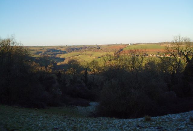
We started from Cold Ashton (at the top left of this map), which has an imposing manor house, and a stunning view - the picture below really doesn't do it justice. From there it was immediately downhill, and into the first mudhole of the day, crossing one of numerous streams and spring run-offs that would feature quite prominently during the afternoon.

The first half of the route was along the Limestone Link way, which is characterised more by mud than limestone, it must be said. It's also characterised by some very well-hidden way markers in places too, so it pays to keep a sharp lookout, and to have reasonable map-reading skills. At one point, the map indicated that the footpath followed the banks of a stream. It would be more accurate to say that the path followed the bed of the stream. This wasn't so bad for Eszter, who was shod with brand new Gore-tex lined boots (even if she didn't want to get them dirty!), but was more of a problem for me, wearing decidedly porous fabric-and-suede approach shoes. A tree-based layback technique along one bank seemed to work quite well, except for the time when the tree I decided to trust with much of my bodyweight turned out not to have any roots, or actually be attached to anything at all.
Mud and navigational issues aside, meandering through rolling meadows and tree-lined hollows, on a beautifully sunlit and surprisingly warm late-January day, isn't a bad way of spending a Sunday afternoon. I'm sure it's actually true of many countries, but there does seem something quintessentially English about having expanses of idyllic countryside only a short drive away from massive conurbations. There's also something quintessentially English about the fact that very few people in the latter take the trouble to visit the former.
The return half of the circult was over Charmy Down, an old RAF airfield now littered with disused buildings, and cows. Actually, that sentence should start "The return half of the circuit when you can actually find out how to get to it...". Yes, the public footpath is marked on the map, and yes, some nice people helpfully told us to "turn right over the bridge". However, the footpath isn't signed at all, and there are two bridges within 20 yards of each other, both of which appear to lead into someone's front garden. After some nervous reconnaisance, half-expecting to be shouted at for trespass, the path was discovered up a dark, narrow alleyway, next to someone's back door, hidden behind a small metal gate. All that was missing was a sign saying "Beware of the Leopard".
This was also the point at which the going got both steep and muddy, with "steep" being the rather more operative word of the two, the path climbing from about 40m to 180m in half-a-kilometre—an average gradient of over 25%, or 1-in-4 in real money. This turned out to be an excellent way of simulating the effects of altitude, at least to the extent of inducing oxygen starvation and incipient exhaustion in a worryingly short space of time. Fair enough, "wold" does mean "rolling", but you do get the feeling that the Cotswolds play fast-and-loose with the term—more rollercoaster than rolling.
Reaching the plateau of the Charmy Down therefore came as a great relief—at least until the fact it is a plateau allowed the rather bitter winter wind to rip through us. (Incidentally, why is it that to reach anywhere called "Down" you almost invariably have to go up?) The windswept airfield is now populated mainly by cows rather than Spitfires and Hurricanes awaiting the order to "scramble", although aircraft do still put in an appearance in the form of microlites and model airplanes.
The cold wind, and the fast-setting sun, contrived to drop the temperature several degrees, which was probably the main reason we elected to take the shorter route back to Cold Ashton, straight across the middle of the old airfield, rather than going right round the edge and then back past Monkswood reservoir.
The last leg of the circuit was pretty easy-going compared with the rest—even to the extent of (unavoidably) being along tarmaced roads at the end. We made it back to the car about 3½ hours after leaving it, and not long before the sun finally set. Okay, it was hardly an expedition to Everest Base Camp, but it certainly made us both ready for the curry (a thankfully mostly pre-cooked curry, having made an excess the night before) that was waiting for us at home.
posted by Jon at 8:53 AM
![]()
![]()
1 Comments:
Great article, Jon
Gill & I only had an 8 mile or so stroll on Sunday...gloriously sunny Surrey Hills, right from our back door
Not quite in your 3 1/2 hour league...I can see there's going to be some healthy training competition over the next 12 months
Steve walked from the pub to the curry house so he's definitely honing his fitness too
Post a Comment
<< Home