
Carry On Camping, Snowdonia Style
 This summer, Eszter and I aimed to combine a holiday with some preparation for Kili. We toyed with the idea of going walking in the Swiss Alps, but eventually opted for Snowdonia, on the basis that a) it's a lot closer, b) we could fit some rock-climbing in, and c) we're just about fluent in one of the languages spoken there.
Following a stop-over at my dad's, in South Staffs, we headed up the A5 on a sunny Monday morning, having sensibly avoided weekend travel, with the inevitable twenty-car tailback behind an Elddis 'Crusader'. A couple of hours or so later, spontaneity* having triumphed over planning, we ended up in Betws-y-Coed with no idea of where to stay. Thankfully, one thing Snowdonia seems to have in abundance - aside from mountains, sheep, rain, midges and tea shops - is campsites. So, having found the tourist information office and grabbed a list of campsites - some reassuringly 'approved', others slightly disturbingly not so - we headed off in search of somewhere.
* also known as 'leaving things until the last possible moment'.
Eventually we picked one based at a farm (Gwern Gof Isaf), between Capel Curig and Llyn Ogwen, practically in shadow of Tryfan, and with panoramic views across to Carnedd Dafydd and Pen yr Helgi Du - perfectly located for walking and a bit of climbing.
The site itself was pretty rudimentary - no actual 'pitches', just more (or, usually, less) flat bits on a large field, with somewhat over-generously described facilities. Yes, there were showers, although the word 'shower' does usually suggest more than one jet of water (and I use the word 'jet' very loosely), and they were hot, if only in the sense that the water wasn't actually frozen. However, on the plus side, the campsite did come with its own integral alarm clock, although it seemed to be set a trifle early. And it didn't have a 'snooze' button.
The first evening was clear and fine, so we walked up a long track opposite the campsite, which went up to the Ffynon Llugwy reservoir. And at least it was downhill on the way back to the tent for supper, with an excellent view of the campsite. The view the next morning, over a nice hot cup of tea (which always tastes great when you're camping, even with UHT milk), was pretty good, too, which seemed to make up for the somewhat basic amenities.
The first full day - Tuesday - demanded we do something vaguely active (aside from making a second cup of tea), so we went into Betws-y-Coed. Somehow I've managed to go to Betws-y-Coed a few times over the years. The first couple of times were when I was at school (staying in The Towers - "an impressive Tudor style building, built in the 1870s, and situated on a magnificent site on the side of the wooded Llugwy Valley in the Snowdonia National Park"), once for an outdoor pursuits week, and later as the base for an A-level Biology Field Trip*. And more recently I camped in the area as a base for a rock-climbing trip. Betws-y-Coed is still a pretty nice place, if inevitably dedicated to the tourism that makes it viable.
* the highlight of which was being 'raided' one morning by the local constabulary, on suspicion of committing an armed robbery the night before. It's a long story...
Anyway, having spent some time buying odds and ends that we'd forgotten to pack, we set off on the first proper walk of the holiday - a round-trip (as, indeed, were all the walks), steeply up through a forest one side of the valley, to Llyn Elsi - a picturesque reservoir above Betws-y-Coed, which has a memorial viewpoint with superb views, including that of Moel Siabod - and then up towards Capel Curig, as far as the road bridge across the Llugwy, returning down the other side of the river, past the famous Swallow Falls, back down to Betws-y-Coed. A late lunch was taken on the banks of the river, dangling weary feet in the cooling - make that 'very chilly' - waters. Whilst it wasn't exactly mountain-bashing, it was a strenuous enough hike to kick things off, in some pretty engaging scenery.
It was on this walk that I toyed with the idea of a Quantum Theory of Exercise. (It's funny... disturbing... what your mind does when you're just walking.) Most of the time, people are idly orbiting life, quite stable in the Couch Potato shell, and it needs a huge amount of 'activation energy' (such as a swift kick up the backside) to jump them into the first few shells of activity, such as Walking To The Shops Rather Than Driving, or Using The Stairs Instead Of The Lift. And the jump to each next shell - the Going Running shell, or the Cross-Training At The Gym shell needs that much more activation energy. I'm not sure where I was headed with this theory, but I may pursue it at a later date and/or when drunk.
The following day - Wednesday - started off rather wet and cold, and only cleared up by lunchtime (a theme to be repeated almost daily, we were to discover), so we decided to get some rock climbing in. The campsite was just up the road from Tryfan Fach, a small outcrop at the foot of Tryfan, with some longish (200') but low-grade routes - perfect for a pleasant afternoon's climbing in the Welsh sunshine.
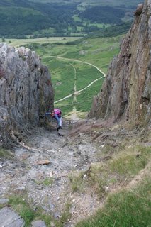
The Welsh sunshine lasted for the first route ('Crack 4'), and into the first pitch of the second, but by the time I was leading the second pitch of 'Slab 1', and getting very close to the exposed edge of the outcrop (on the left hand side of this picture) a pretty hefty storm broke over the top of Tryfan, with some of the strongest winds I've climbed in for quite a while. After reaching the top I was now stuck just sitting there and belaying, but Eszter had all the fun of having to scale the increasingly wet and cold rock. Some people have all the luck! With no sign of the wind and rain abating, we called it a day after two routes, and headed back to base camp.
Today happened to be my birthday, so we went into Betws-y-Coed for meal, ending up at one of the several pubs the town still has (food good, Abbot Ale even better). We then called in at the local shop, to see what we could take back to the tent for pudding. Having previously scoffed an excellent bread-and-butter pudding we got from there on our first day, their home-made pies looked like just the job. Just two were left - golden brown things, with two small holes in the top. According to a note taped to the counter, two holes meant cherry (one hole was apple, two 'slots' was blackberry, etc).
"A cherry pie, please", I asked.
"We haven't got any," came the assistant's reply.
"But those two pies both have two holes," I incisively countered
"Yes, but they're rhubarb," came back the crushing rejoinder.
"So why have they got two holes?"
"To confuse people".
There being no good answer to that, we walked away from the counter and started looking at biscuits. We must have looked really dejected, because a minute later the assistant came up to us and said "We've just taken tomorrow's pies out of the oven. We don't normally sell them straight away, but you can have one of them if you like - there's apple, strawberry, blackberry and blueberry." No contest. "Blueberry, please". It was still warm when we got back to the tent, and whilst plastic picnic plates may not complement haute cuisine, the pie tasted ambrosial to me.
Meantime, the wind and rain had intensified as the evening wore on. By the time we crawled into our sleeping bags, the front door flap was billowing like a spinnaker, and one rear corner of the tent - which should have looked like the right-hand side of this one - was bending inwards by more the amount it should have been bending outwards.
Diagnosis? The guy rope no longer attached to the ground.
Prognosis? Tent liable to imminent collapse.
Treatment? Jon must crawl out of his cosy sleeping bag and stumble around in the dark, in the rain, in a howling gale, trying to the kick tent peg into stony ground wearing sandals.
Dosage? Four or five times a night.
We knew it had been windy when, next morning, we saw the neighbours had attached their tent to their car. And someone later told me that a tent they'd seen pitched the previous evening had vanished by the morning - the people had given up trying to repeatedly secure it and retreated to their car to sleep.
"Is it often this windy?" I asked the woman at the farm..
"Oh yes," she replied.
"See that barn?" she continued, pointing to a building just behind where we'd had our tent - a building with a galvanized metal roof bolted to it. "I've seen that roof just peeled off."
So, we decided to declare it a 'rest day', and move to a slightly less exposed campsite, a bit further south in Snowdonia, where there had so far seemed to be fewer clouds in the sky. The rest of the morning was spent packing - including wrestling the tent into its bag in a gale force wind. Quite strenuous enough for an alleged 'rest day', thank you very much. By the time we left the campsite, it was getting deserted, as many other people had clearly also had enough of the conditions there.
After heading down to Beddgelert we found our way to the Forestry Commission campsite, just outside the town. This site was diametrically different to the first one - highly organised, obvious pitches, lots of trees for shelter (obvious really, given it's in a forest), free hot showers (that really are both hot and showers), hot water for washing-up, and a small shop (albeit understocked and overpriced). Plus they sold butane too - an increasing concern, given that we had no idea how long ours was going to last.
To be honest, the Forestry Commission campsite was a bit too organised for me, with rather too many caravans & motorhomes and people who seemed more concerned about how to improve their TV reception than actually getting out and about. Oh, and children, too. Whilst I think camping is a really excellent activity to take children on - it teaches them some self-sufficiency and (hopefully) gets them into nature and exercise - I'd just rather they weren't taken quite so close to my tent. Nor should they be given footballs, scooters and - I really can't stress this last one too strongly - cap-guns. However, having proper amenties and a sheltered pitch was infinitely preferable to cold showers and expecting the tent to leave the ground at any moment, so I shouldn't complain.
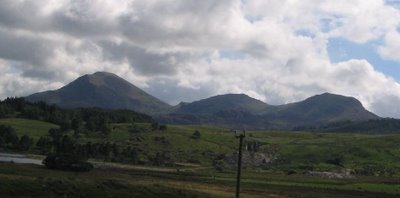
The following day - Friday - saw a return to the walking schedule, with a traverse of the three 'Moels' (a 'moel' is a 'bare hill') that are right by the campsite - Moel Hebog, Moel Yr Ogof and Moel Lefn. They're not the highest peaks (Hebog is only 782m, and the other two are around 650m), but there's plenty of ascent and descent involved - good for building up those calves - and the final stretch up Hebog involves quite a degree of scrambling. For some reason we didn't take any pictures on this walk (I'm guessing the weather was very overcast), but the one below shows the three Moels - we walked right across the top of all three (left to right), before a very muddy return through Beddgelert Forest to the campsite.
One thing we had decided that we definitely needed to do was a long walk on two successive days (Kili obviously requiring several consecutive days - and long ones at that - of hard walking). So, the Saturday morning saw us heading off to go up Cnicht. Again, it's by no means the highest of peaks - 'only' 689m - but it's a very 'mountain shaped' hill (and even more so in winter) and is known as the 'Matterhorn of Wales' as a result. And anyway, the name alone is reason enough to climb it.
It's quite a slog up Cnicht from Croesor, and we thought we were doing well until a woman (a middle-aged woman, at that, if it's not ungallant to mention it) ran past us, her teenage son in tow. A bit further along we caught up with her husband, who explained that it was the annual Cnicht Fell Race in three weeks, and she was getting a first look at the course. Okay, she was in lightweight shoes, rather than heavy boots, and wasn't carrying a pack full of spare clothes, food, camera and water, but it was still fairly demoralizing having someone zip past you like a mountain goat. That said, she stopped her reconnaisance well short of the actual summit (not that I blame her), so we trudged onwards and upwards, as she went back down for some bara brith and a cuppa.
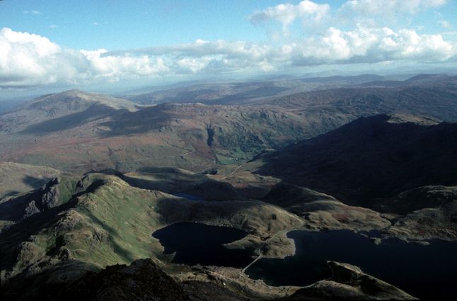
The views from the top of Cnicht - like this, this (one of my favourites pictures from the holiday, taken by Eszter), and this - certainly make the long hard slog up there worth the effort.
It's quite a long way down, too, as the route goes right along the ridge and then down through some very boggy areas on the edge of a couple of lakes. And it doesn't help if you go quite a long way in the wrong direction, and have to break a path over the top of a hill to find your way back the correct route. (Yes Eszter, you were right. This time, anyway.) Part way along the walk down the path cut across a tramway incline - it must be hard work going down one of those, we thought, as we followed the increasingly gentle path back to the car park in Croesor.
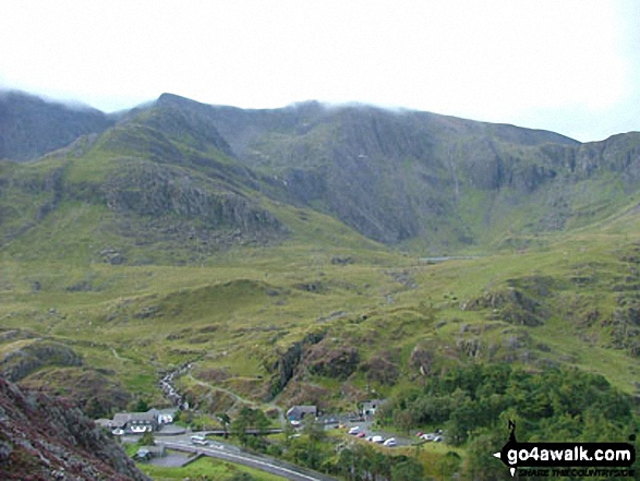
We were both happy to have done a second consecutive day's walking, up some steep and rugged terrain. But the weather on the Sunday morning was utterly wet and miserable, and didn't make us feel like going anywhere much. It brightened up a bit by early afternoon, so we decided to do a bit more climbing to salvage something from day. We drove round to the far end of Llyn Ogwen (passing the still half-deserted original campsite), to the car park by Ogwen Cottage (bottom middle of the picture). From here a path goes up to Llyn Idwal and Twll Du (also known as 'The Devil's Kitchen'), and then on round the Glyderau. We were aiming to climb on Clogwyn y Tarw (The Gribin Facet), which requires going up to Llyn Idwal, and then breaking off left and clambering over a load of boulders that were originally attached to the cliff face you're about to climb up.

It was here we saw one of the strangest sights I've seen out walking. As we started up the path to Llyn Idwal, we were passed by a large group of people - maybe 20 in all - heading the same way. Nothing unusual about that - it's August in Snowdonia, after all, and lots of groups take to the hills. Quite so. Except that this group was composed entirely of Orthodox Jews, in full Hasidic-style attire - white shirts, black trousers, long black coats, black hats, and black 'city' shoes - much like the people in the picture. Perhaps I'm too conservative in my views on hiking clothes, but they didn't seem best equipped for the mountains, especially if the weather turned nasty. Still, they seemed happy enough, so good luck to them.
The climbing route we decided on was 'Angular Chimney', a climb of two pitches, which goes up the 'corner' where a large 'bastion' of rock abuts the main cliff-face (the angle), and then through a narrow 'chimney' to the top (the, err, chimney). We spent quite a while - as usual - getting into our harnesses & boots, selecting enough protection (the stuff you put in cracks in the rock to help prevent your falling all the way down), and making sure the rope was running freely. Just getting up to the start of the climb involves quite a scramble, and requires you to invest a seriously unwise amount of faith in the ability of plant roots to support a human body.
Now, although I've been climbing on and off for about 10 years, I'd be the first to admit that I'm not especially good at it, and that I'm somewhat heavier now than when I started. But I've climbed some quite respectable routes in my time, and being quite tall usually allows me to reach holds that elude other people's desperate fingers. And I'd even climbed this very route before (about 8 years ago). So why did I have so much trouble this time?
Now, although I've been climbing on and off for about 10 years, I'd be the first to admit that I'm not especially good at it, and that I'm somewhat heavier now than when I started. But I've climbed some quite respectable routes in my time, and being quite tall usually allows me to reach holds that elude other people's desperate fingers. And I'd even climbed this very route before (about 8 years ago). So why did I have so much trouble this time?
Just getting off the ground to start with was hard enough - yes, there was quite a nice hand-hold on top of the jutting out base of the 'bastion', but there were no useful footholds at all. In the end it required the sort of strenuous heave-ho more associated with the 'thuggier' routes on Grit stone (such as at The Roaches, in the Peak District). How can this possibly be graded the same as the nice easy route we did the other day? Then it got worse.
The problem was that the corner was dank and dark, and the face next to it hadn't dried out much at all, meaning that where the rock was covered with moss and lichen - which seemed to include all the footholds - it was as slippery as ice. I managed to clamber up about 50' or so of the first pitch, my dirty green knees and elbows a visible testament to the 'as many points of contact as possible' school of climbing I had adopted out of necessity. Then I reached an impasse. The moves needed to carry on were pretty obvious. A brief traverse out onto the face, grab hold of a nice convenient flake, find a couple of good foot-holds, and go back up into the corner. The only slight flaw with that plan was the complete absence of any foot-holds with appreciably more friction than Teflon.
Okay, I was roped up, and wouldn't have fallen too far if I slipped. But my last piece of protection was already a little way below me, and there was nowhere to put more in until after I was back in the corner, about another 15' higher up. Moreover, a fall into a corner tends to be rather more unpleasant than one straight down a cliff face, as there's just more rock to collide with. I gave it three attempts (the last one was so close - really!) before deciding that 'he who lowers-off and walks away, lives to climb another day'. Then I got Eszter to lower me back down, and we went back to the campsite.
You can't really come to Snowdonia and not go up Snowdon. We'd climbed it earlier in the year, as a Kili team-building exercise, and found it an 'educational experience' as far as our current fitness levels were concerned. So on Monday it seemed a good idea to see what difference three months of training (stop laughing) had made. The obvious route, based on where were were camped, was the Watkin Path, which had the attraction of being one I've never done before*, and also being the route that starts from the lowest point - just 60 m above sea level - giving an overall height gain of 1025m by the time you reach the top. A less obvious attraction is that the sentry-point scenes of 'Carry on Up the Khyber' were filmed on the Watkin Path.
* Up to now I'd done Rhydd Du (the Kili team assault in April), up Pyg & down Miners, and the Snowdon Horseshoe (in winter).
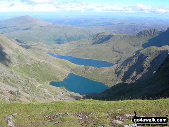
The problem with the Watkin path is that it has a deceptively civilized start - the path is paved with large flat stones, and the ascent up Cwm Llan is pretty gradual. Indeed, it used to be possible to drive a coach and horses up to the quarry that marks about the half-way point up the path. Of course, such a gentle start comes at a price, and after the quarry the path takes a sharp turn up the hillside. It's still well marked, but rather steeper. Eventually, the path levels out a bit, where it reaches Bwlch y Saethau (the Pass of Arrows) - said to be where King Arthur was fatally wounded in his last battle, with Sir Bedivere carrying Arthur down to Llyn Llydaw to be taken away by the 'fair maids of the mountains', casting the sword Excalibur into Llyn Glaslyn along the way. (Glaslyn the nearer, Llydaw the further, in the photo.)
Having started the walk a bit late in the day (at midday), we began to meet a few people who were already on their way down, some of whom were extremely encouraging, passing helpful comments such as "the hardest bit is next", "it gets much steeper very soon" and "it's quite dangerous up there, you know...". They weren't wrong either. After a bit of a zig-zag, the path takes a final turn, heading for the eastern end of Bwich Main, pretty much straight up the side of the mountain. The path, such as it is (which isn't much by now), is basically a mixture of scree and larger rocks - all very unstable, and with the potential of a long and painful fall should you slip. Thankfully it's only a short stretch (we covered it in 20 minutes), but it's certainly very strenuous, and needs some care.
Once you reach the 'saddle' at the end of Bwlch Main, it's only a few minutes more up to the summit, and the hideous bunker-like monstrosity of the café (mercifully now scheduled for demolition and replacement with what will hopfully be a more visually sympathetic 'visitors centre'). Time taken for the whole ascent: 2½ hours. I've no idea if that's good, bad or just average for the Watkin Path, but we both felt pretty good about it. As usual, the summit area was absolutely heaving with people, the vast majority of whom would have come up from Pen-y-Pass. And it goes without saying that as we'd gone up the cloud base had come down, so there were (yet again) no views to be had. So, staying only for the obligatory trot up to the trig point, we headed off down again.
I have an aversion to going back the same way, so rather than descend via the Watkin Path, we decided to do a round-trip, along the South Ridge to Bwlch Cwm Llan and then down into the valley. (This is the start of the same route down we took on the Kili team trip in April, but you then turn left rather than right at the end of the South Ridge). Descending into the valley is quite tricky, as it's another very loose slope (although not as bad as going down Watkin would have been), but after that the going gets a lot easier, as you follow a well defined path.
Soon you find yourself following the route of the South Snowdon Slate Works tramway, used to take slate from the quarries, eventually reaching a point where the suggested path takes a detour down and round the base of a hill, and the tramway carries on straight ahead, apparently providing a short-cut. Just out of curiosity, we carried on along the route of the tramway. Oddly, the tramway seemed to go gently up, which didn't augur too well for how we were going to go down the other side of the hill to rejoin the path. When we reached the 'head' of the track, all became horribly clear - the way down was a tramway incline. Straight down, cut through solid rock. Ever game for a laugh we decided to give it a go...
The problem was that the corner was dank and dark, and the face next to it hadn't dried out much at all, meaning that where the rock was covered with moss and lichen - which seemed to include all the footholds - it was as slippery as ice. I managed to clamber up about 50' or so of the first pitch, my dirty green knees and elbows a visible testament to the 'as many points of contact as possible' school of climbing I had adopted out of necessity. Then I reached an impasse. The moves needed to carry on were pretty obvious. A brief traverse out onto the face, grab hold of a nice convenient flake, find a couple of good foot-holds, and go back up into the corner. The only slight flaw with that plan was the complete absence of any foot-holds with appreciably more friction than Teflon.
Okay, I was roped up, and wouldn't have fallen too far if I slipped. But my last piece of protection was already a little way below me, and there was nowhere to put more in until after I was back in the corner, about another 15' higher up. Moreover, a fall into a corner tends to be rather more unpleasant than one straight down a cliff face, as there's just more rock to collide with. I gave it three attempts (the last one was so close - really!) before deciding that 'he who lowers-off and walks away, lives to climb another day'. Then I got Eszter to lower me back down, and we went back to the campsite.
You can't really come to Snowdonia and not go up Snowdon. We'd climbed it earlier in the year, as a Kili team-building exercise, and found it an 'educational experience' as far as our current fitness levels were concerned. So on Monday it seemed a good idea to see what difference three months of training (stop laughing) had made. The obvious route, based on where were were camped, was the Watkin Path, which had the attraction of being one I've never done before*, and also being the route that starts from the lowest point - just 60 m above sea level - giving an overall height gain of 1025m by the time you reach the top. A less obvious attraction is that the sentry-point scenes of 'Carry on Up the Khyber' were filmed on the Watkin Path.
* Up to now I'd done Rhydd Du (the Kili team assault in April), up Pyg & down Miners, and the Snowdon Horseshoe (in winter).
The problem with the Watkin path is that it has a deceptively civilized start - the path is paved with large flat stones, and the ascent up Cwm Llan is pretty gradual. Indeed, it used to be possible to drive a coach and horses up to the quarry that marks about the half-way point up the path. Of course, such a gentle start comes at a price, and after the quarry the path takes a sharp turn up the hillside. It's still well marked, but rather steeper. Eventually, the path levels out a bit, where it reaches Bwlch y Saethau (the Pass of Arrows) - said to be where King Arthur was fatally wounded in his last battle, with Sir Bedivere carrying Arthur down to Llyn Llydaw to be taken away by the 'fair maids of the mountains', casting the sword Excalibur into Llyn Glaslyn along the way. (Glaslyn the nearer, Llydaw the further, in the photo.)
Having started the walk a bit late in the day (at midday), we began to meet a few people who were already on their way down, some of whom were extremely encouraging, passing helpful comments such as "the hardest bit is next", "it gets much steeper very soon" and "it's quite dangerous up there, you know...". They weren't wrong either. After a bit of a zig-zag, the path takes a final turn, heading for the eastern end of Bwich Main, pretty much straight up the side of the mountain. The path, such as it is (which isn't much by now), is basically a mixture of scree and larger rocks - all very unstable, and with the potential of a long and painful fall should you slip. Thankfully it's only a short stretch (we covered it in 20 minutes), but it's certainly very strenuous, and needs some care.
Once you reach the 'saddle' at the end of Bwlch Main, it's only a few minutes more up to the summit, and the hideous bunker-like monstrosity of the café (mercifully now scheduled for demolition and replacement with what will hopfully be a more visually sympathetic 'visitors centre'). Time taken for the whole ascent: 2½ hours. I've no idea if that's good, bad or just average for the Watkin Path, but we both felt pretty good about it. As usual, the summit area was absolutely heaving with people, the vast majority of whom would have come up from Pen-y-Pass. And it goes without saying that as we'd gone up the cloud base had come down, so there were (yet again) no views to be had. So, staying only for the obligatory trot up to the trig point, we headed off down again.
I have an aversion to going back the same way, so rather than descend via the Watkin Path, we decided to do a round-trip, along the South Ridge to Bwlch Cwm Llan and then down into the valley. (This is the start of the same route down we took on the Kili team trip in April, but you then turn left rather than right at the end of the South Ridge). Descending into the valley is quite tricky, as it's another very loose slope (although not as bad as going down Watkin would have been), but after that the going gets a lot easier, as you follow a well defined path.
Soon you find yourself following the route of the South Snowdon Slate Works tramway, used to take slate from the quarries, eventually reaching a point where the suggested path takes a detour down and round the base of a hill, and the tramway carries on straight ahead, apparently providing a short-cut. Just out of curiosity, we carried on along the route of the tramway. Oddly, the tramway seemed to go gently up, which didn't augur too well for how we were going to go down the other side of the hill to rejoin the path. When we reached the 'head' of the track, all became horribly clear - the way down was a tramway incline. Straight down, cut through solid rock. Ever game for a laugh we decided to give it a go...
 The first section, through the cutting, was basically a reverse scramble, and easier done down-climbing 'backwards' (facing the rock) rather than walking forwards. After that, the middle section became very loose scree, which I elected to 'run' (as the scuffs on my boots now record) and Eszter, more sensibly perhaps, to walk, and finally a steep grassy slope. Looking back up it, not only did it seem something of an achievement - if a quite unnecessary one, given the existence of a perfectly good path round base of the hill - but my admiration (and sympathy) for the Welsh slate miners who built and worked the tramway grew further - hard men, and a very hard life. Snooker tables everywhere are their memorials.
The weather having held up pretty well all day, it stayed fine and dry for the evening, so we decided to risk a celebratory barbecue. A respectable amount of meat was bought from the shop in Beddgelert (currently for sale, incidentally), along with a modest supply of beer (we were supposed to be being healthy, after all). Thankfully, lighting the barbecue didn't conjour any rain, and we enjoyed a very relaxing (and filling) evening.
Throughout the holiday we'd been consulting the Met Office mountain weather forecasts for Snowdonia, which get posted up daily in various shops throughout Snowdonia. Whilst they hadn't been especially accurate, they had seemed to be consistently on the optimistic side. Heavy storms were predicted for later in the week, so we thought it a good idea to get another day's walking in on the Tuesday, in case it was our last chance. We'd been lent a book of Snowdonia walks, and it described a long-ish circular walk from Beddgelert along the length of Llyn Dinas, then back through the Nanmor Valley and the Pass pf Aberglaslyn to Beddgelert. It also said it was "without strenuous climbing or difficult terrain", which just goes to show you definitely can't believe everything you read.
To be fair, it was a very pleasant walk. Or rather, it would have been, had it not rained continuously for the last 4 hours of the route. We'd brought waterproofs with us, but given the way Welsh rain has of starting gently before setting in for the day, we were already pretty wet before it was obvious we were going to need them. Eszter donned her jacket, but I chose to stay in just my windproof + base layer, on basis that a) I couldn't get any wetter (it turned out that I could, actually), and b) I'd dry out very quickly if the rain ever stopped (it didn't). To add to the fun, one of the shoulder straps of my new backpack (bought just a couple of days before the holiday) decided to break - thankfully towards the end of the walk - so I was left having to hold the loose end of the strap to keep the pack* balanced.
* a Karrirmor 'Airspace 25', should you wish to avoid buying one.
With much of our clothing now wet or generally clammy (as things kept in tents tend to get) , our boots now sodden (even if the Goretex lining had kept our feet dry), and with the weather forecast to deteroriate, we decided to bring our Snowdonia trip to an end, and head for home on the Wednesday. There's not much to say about the journey back through Wales, except that there's a very good fish & chip shop in Newtown (well, there has to be something good about the place).
Thus ended our Summer Training Camp. All-in-all, I think we managed to combine a much needed holiday for both of us with a useful 10 days of 'getting some miles in' on the hills. It also showed that we could spend day- after-day, together, including couped-up in a tent, without the distractions of TV or the Internet, without killing each other (although I did see a dangerous glint in Eszter's eyes once or twice...).
It wasn't a conventional 'relaxing holiday', perhaps, but it worked for us!
posted by Jon at 9:45 PM
2 comments
![]()
![]()