Thursday, February 02, 2006

A Fool and his money are.....very generous!

this is an audio post - click to play

Monday, January 30, 2006

Sponsorship information and options

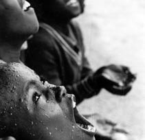
(Image reproduced from the World Vision website with their kind permission)
I posted some general information in earlier articles about why I'm doing this crazy Kili attempt with The Kili 5 in February 2007 and why I'm aiming to raise £25,000 for World Vision - here's a bit more stuff about sponsorship options and where the funds will go. And I know there's over a year to go but £25,000 is going to be A Big Ask / A Tall Order (depending on which side of the pond you are) so I'm starting early...
Individuals:
Please go to the bmycharity* site I have set up, where you can use a credit card to pay securely online. This will allow an immediate contribution which can be grossed up for tax relief - at no extra cost to you - if you tick the giftaid it box. Any funds committed now will be sent over to Tanzania by World Vision* to get the ball rolling on specific projects in Tanzania sooner rather than later (more detail on the World Vision projects below)
If you'd rather wait until we've actually been to Tanzania and suffered trying to yomp up Kili, then please pledge an amount by emailing me details of how much you'll sponsor...and any performance conditions:
- x£ all or nowt for reaching the summit
- x£ per 1,000 metres of ascent (target is 5,895....sounds like 6,000 to me)
- x£ per 1,000 feet of ascent (19,710 but let's call it 20,000 between friends)
- x£ for each time I throw up (from altitude sickness rather than the excesses of a previous life)
- whatever sadistic or creative condition you can dream up
Companies:
Rather than go through the bmycharity site, more of your generous sponsorship will find its way through to the World Vision* project (because I don't think companies can't sign up for the giftaid it option) if you could please send any funds direct to World Vision as follows, quoting Kili50:
Peter Halewood
Major Donor Executive
World Vision (UK)
World Vision House
Opal Drive, Fox Milne
MK15 0ZR
Cheques should be made payable to World Vision UK or I'll get hold of the bank details if you'd prefer to make a direct bank transfer
Of course the pledge options above apply if you'd rather see us suffer first before committing sponsorship!
*World Vision:
World Vision normally commit to send 78% of funds raised on to the charitable projects, with the remainder supporting their general running costs and other commitments. But I have received confirmation from Peter Halewood of World Vision that because of the size of this fundraising effort and since the funds are being raised with specific projects in mind, at least 97% will directly benefit the World Vision Tanzanian projects, which is fantastic
*bmycharity:
bmycharity charge just over 5% of the total value of the donation including gift aid, to cover their own admin costs. But because they encourage people to claim gift aid they estimate that on average, even after their charges have been deducted, the charity will have more than 13% more to spend on service provision than if the funds were donated by traditional means - so tick away on those giftaid it boxes!
But where will the funds really go......?
I know that these days we're all inundated with requests to give generously, and that sometimes the charity is either dodgy or gobbles up a huge % of our hard earned cash to finance their own bloated organisations. I know from personal experience that World Vision is a very professional and caring charity, and I've tried to ensure that nearly 100% of everything you can cough up will find its way to the intended - and very worthy - destination:
Key facts about Tanzanian (from World Vision Kisiriri School Project report)
  • Population: 36m
  • Life expectancy: 43.5 years
  • 165 of every 1,000 children die before their 5th birthday
  • 29% of under 5s are underweight for their age
  • 22.9% of the adult population can't read or write
  • 32% of the population don't have access to safe clean water
  • 8.8% of the adult population are infected with HIV/AIDS

Any sponsorship we can raise from this Kili50 effort will specifically benefit the Kisiriri Area Development Project, a remote area in the central north of Tanzania, comprising the children and families in 19 villages. More details of the actual World Vision projects in Kisiriri ADP that your sponsorship will help will follow as the year progresses, but rest assured that the total target of £25,000 will change lives. What I like about World Vision is that they encourage local communities to help themselves over the long term, rather than throw money at a problem and hope for a short term solution, and disappear...the ADP started in 2004 and will be supported by World Vision for the next 15 years

I realise that I'm visiting their country just for a personal whim and that the cost of the trek represents more money than most Tanzanians can ever dream about...but hopefully raising £25,000 to benefit very specific projects in a small area of the country will at least give a little back to the country with a Very Big Mountain

I might have very different feelings after the attempt, of course, but right now I would appreciate any support you can give for the Kili50 initiative

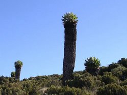
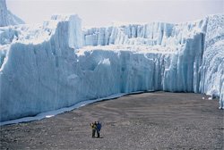
And you can follow the Kili 5's efforts by bookmarking this Blog site now. Take a look at some previous articles to see the majesty of the mountain and its 5 distinct zones; my disastrous commute getting me out of circuits; the wonders of VO2MAX; why we're taking the Machame route...and going forward see how fit Steve is by the end of the year (he's progressed to walking to the car this month), how our Snowdon jaunt pans out, how the sponsorship effort goes...and much much more thrilling stuff

And finally, if any of this inspires you rather than makes you feel a bit queasy with the worthiness (and challenge) of it all, then it's not too late! But it soon will be. There are just a few places left in the Explore group leaving on February 23, 2007 with the Kili 5 in it

Ok, this really is the last word...please email this Blog link to all your contacts so that they can hopefully sponsor and send on to their own contacts. We need all the help we can get to raise the £25,000

Thanks for listening...and hopefully for giving

The Cotswold Rollercoaster

Time for my first appearance on this blog, I think. Andrew's entries have already set high standards, and I have doubts this will live up to them. (He's also an accomplished flatterer and embroiderer-of-truths, too, it seems. His suggestion that I'll "meander up Kili barely breaking sweat" certainly isn't borne out by any recent experience of strenuous activity that I've had, such as going upstairs, or walking to the shops.)

Yesterday—Sunday—saw Eszter and I exploring the badlands of the Southern Cotswolds, doing a few miles round St Catherine's and Charmy Down. The Southern Cotswolds are rather the poor cousin of their more northerly relatives—eg, the better known chocolate-box picture areas around Stow-on-the-Wold and Bourton-on-the-Water—which is a shame, as they're no less enchanting. I suspect they suffer from having Bath as a very near neighbour.

The Cotswolds may not be the first area that comes to mind for alpine training. However, whilst the whole area we walked in doesn't rise much above 200m, it demonstrated a remarkable ability to go steeply up and down a lot, and, when not going up or down, to be very muddy. On one occasion it contrived to showcase its talents by being steeply uphill and muddy.

Our route took us along part of the Limestone Link, a 36 mile path linking the Cotswolds to the Mendips, which follows the Kennet & Avon Canal for some of its way. (Incidentally, the Kennet & Avon canal has a major place in the history of geology. The Resident Engineer was no less a man than William "Strata" Smith, who—fascinated by the layered rock formations that were revealed as the canal was excavated—devoted his life to geology, producing the world's first true geological map. But I digress...)

We started from Cold Ashton (at the top left of this map), which has an imposing manor house, and a stunning view - the picture below really doesn't do it justice. From there it was immediately downhill, and into the first mudhole of the day, crossing one of numerous streams and spring run-offs that would feature quite prominently during the afternoon.

The first half of the route was along the Limestone Link way, which is characterised more by mud than limestone, it must be said. It's also characterised by some very well-hidden way markers in places too, so it pays to keep a sharp lookout, and to have reasonable map-reading skills. At one point, the map indicated that the footpath followed the banks of a stream. It would be more accurate to say that the path followed the bed of the stream. This wasn't so bad for Eszter, who was shod with brand new Gore-tex lined boots (even if she didn't want to get them dirty!), but was more of a problem for me, wearing decidedly porous fabric-and-suede approach shoes. A tree-based layback technique along one bank seemed to work quite well, except for the time when the tree I decided to trust with much of my bodyweight turned out not to have any roots, or actually be attached to anything at all.

Mud and navigational issues aside, meandering through rolling meadows and tree-lined hollows, on a beautifully sunlit and surprisingly warm late-January day, isn't a bad way of spending a Sunday afternoon. I'm sure it's actually true of many countries, but there does seem something quintessentially English about having expanses of idyllic countryside only a short drive away from massive conurbations. There's also something quintessentially English about the fact that very few people in the latter take the trouble to visit the former.

The return half of the circult was over Charmy Down, an old RAF airfield now littered with disused buildings, and cows. Actually, that sentence should start "The return half of the circuit when you can actually find out how to get to it...". Yes, the public footpath is marked on the map, and yes, some nice people helpfully told us to "turn right over the bridge". However, the footpath isn't signed at all, and there are two bridges within 20 yards of each other, both of which appear to lead into someone's front garden. After some nervous reconnaisance, half-expecting to be shouted at for trespass, the path was discovered up a dark, narrow alleyway, next to someone's back door, hidden behind a small metal gate. All that was missing was a sign saying "Beware of the Leopard".

This was also the point at which the going got both steep and muddy, with "steep" being the rather more operative word of the two, the path climbing from about 40m to 180m in half-a-kilometre—an average gradient of over 25%, or 1-in-4 in real money. This turned out to be an excellent way of simulating the effects of altitude, at least to the extent of inducing oxygen starvation and incipient exhaustion in a worryingly short space of time. Fair enough, "wold" does mean "rolling", but you do get the feeling that the Cotswolds play fast-and-loose with the term—more rollercoaster than rolling.

Reaching the plateau of the Charmy Down therefore came as a great relief—at least until the fact it is a plateau allowed the rather bitter winter wind to rip through us. (Incidentally, why is it that to reach anywhere called "Down" you almost invariably have to go up?) The windswept airfield is now populated mainly by cows rather than Spitfires and Hurricanes awaiting the order to "scramble", although aircraft do still put in an appearance in the form of microlites and model airplanes.

The cold wind, and the fast-setting sun, contrived to drop the temperature several degrees, which was probably the main reason we elected to take the shorter route back to Cold Ashton, straight across the middle of the old airfield, rather than going right round the edge and then back past Monkswood reservoir.

The last leg of the circuit was pretty easy-going compared with the rest—even to the extent of (unavoidably) being along tarmaced roads at the end. We made it back to the car about 3½ hours after leaving it, and not long before the sun finally set. Okay, it was hardly an expedition to Everest Base Camp, but it certainly made us both ready for the curry (a thankfully mostly pre-cooked curry, having made an excess the night before) that was waiting for us at home.

Sunday, January 29, 2006

Targets, targets, targets

If the truth be told I drifted through the first 30 (OK...40) something years of my life somewhat aimlessly. Underachieving, I'll probably admit. I suppose I've done OK and I'm not complaining, but one thing that has finally sunk in is that I always need a target. Focus. Something very specific to strive towards
Mrs M will probably reckon that this epiphany coincided with meeting her. She might be right
And right now I am incredibly motivated towards attempting to climb Mount Kilimanjaro in Tanzania in February 2007, to mark my 50th birthday in May 2007 and also to try and raise £25,000 for World Vision. Please see the earlier article World Vision overcomes South West Trains for some more information on World Vision and click the link on the right Sponsor Andrew here for more information
Anyway, I suppose I'm reasonably fit for a 48 year old with a dodgy back, more allergies than you can point a hypodermic needle at, and a weird eating disorder...but I recognize that I ain't got a chance of getting to the top of 5,895m / 19,710 feet if I'm not in optimum physical shape..as fit as someone of my advancing years can be, at any rate. And mental condition too, but that's an entirely different challenge to be thought about in the next 13 months
Mrs M and I joined the Charterhouse gym shortly after the excesses of Christmas. I'm 48 and she's 44 in a month's time...we definitely need some motivation and some very tangible targets. As for the rest of the Kili 5, they probably don't have to plan the fitness thing quite as meticulously or far ahead as we old farts do (that's me, Gill..not you, obviously). Jon (42) is a rangy sort of character and build, and I reckon he'll meander up Kili barely breaking sweat; Esther/Eszt/Est is a mere 25, in the prime of her life and taking a healthily cautious view of her chances which should help by all accounts. Steve, 21 later this month, left the prime of his life in Oz and NZ a couple of years ago but his training is definitely on track: I walked to the car yesterday
I had a health and fitness check thingy yesterday. I need that benchmark...a measure of where I am today compared with where I need to be on February 23, 2007 when we see the snow-capped peak for the first time. And I know it's a bloody long way in every sense


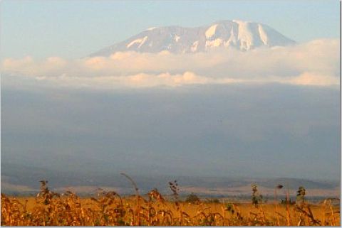
Here's what I got from a very pleasant 30 minutes with Julie:

Height: 181cm (target = 185cm)

Weight: 73kg (hmmm...I've been 75kg for years now. Not sure why I've dropped a couple of kg recently, especially after a lot of rum punch and jerk chicken at Christmas). Might need to bulk up a bit to get my puny frame up 5,895m in sub zero temperatures

Blood pressure: 118/74mm/Hg. Fine. 118/74 compared with the normal (120/80) range. Stick to a healthy diet, minimising the intake of saturated fats and keep up with your regular aerobic exercise. There's no saturated fat in the weekend bacon butties, right?

Body fat: percentage body fat refers to the proportion of your body fat that is comprised of fat. Your assessment indicated a level of 18.1% which is within the recommended range of 14-20%. Really push yourself on the cardiovascular machines...at the end of the day the harder you work, the better the results will be.Thanks, Julie, but sometimes I just don't feel like really pushing myself on the treadmill after a long day sweating for The Motley Fool and wrestling with South West Trains

Flexibility: this is an important factor for injury prevention and to assist in day to day activities. Your flexibility in the sit and reach test, particularly in the hamstrings could be improved. You obtained 20 cms, which is below the minimum range (22-31 cms) for your age. Flexibility can be increased by taking more time to stretch properly before and after exercise. Oops. This one hurt. I'm blaming the pathetic hamstring bendiness on my bad back...but I know I've never stretched properly before or after exercise, I just want to get on with it. Definitely a could do better area. I'll aim for an ambitious improved target of 24 cms

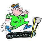
Stamina (aerobic fitness): basically the ability of the heart, lungs and rest of the cardio respiratory system to deliver oxygen to the exercising muscles.
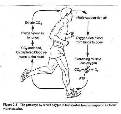
From the test we carried out on the treadmill I have worked out your aerobic fitness (running comfortably on the treadmill for 1 mile / 1.6 km while hooked up to a heart monitor thing...I think it took me about 8 minutes) and my heart rate at the finish was 139 bpm

VO2MAX = maximum oxygen uptake (ml/kg/min). In other words the maximum capacity of oxygen you can get to your muscles in ml, per kg of body weight per minute. You obtained 57.5 ml/kg/min, which is in the EXCELLENT category for your age group (40+) so you should be very pleased. Too right I'm pleased, Julie...this is going to be crucial to try and get to Kili's summit where we'll have less than half of our normal oxygen intake, apparently. Hoorah

Here's how you can work out your own VO2MAX in the future (are you ready for this?):

108.44 - (0.164 x weight)(kg)) - (1.438 x mile jog time (m)) - (0.193 x final heart rate)

This formula is for the guys, by the way, so get measuring, Jon & Steve. I'm targeting a significant improvement, but not quantifying it yet! Obviously the higher it is the more oxygen you can uptake and the fitter you are

I'm trying to persuade Gill to take a similar test to benchmark her own fitness level, and hopefully she can get the girlies' VO2MAX magic formula if she & Est are vaguely interested in any of this mumbo jumbo

Water: for the amount of exercise you do your water percentage was good. You were within the recommended range (55-65%) with 60.1%. It is recommended that for an active person two and a half litres of water should be drunk per day. Apparently this water intake is absolutely critical during the Kili climb...if you don't drink enough you'll dehydrate and don't stand a chance of dealing with the altitude. And of course if you do drink enough you spend half the day peeing. Which is a good thing because it forces you to rest a lot

Conclusion: your aerobic fitness is excellent so just work at maintaining that. Your flexibility should be improved though just remember to stretch properly before and after your workout sessions and hold your cool down stretches for longer than your warm up stretches. Other than that, continue what you're doing. Well done, keep up the good work. And of course you're allowed 4 pints of lager and a curry every Friday, Saturday and Wednesday night

OK, I made up that last bit but otherwise not too shabby for an old git, eh? Still got something to aim for in the next 13 months so that I've got a fighting chance of summiting Kili, though. Thanks, Julie for an enjoyable and thought-provoking experience. The fitness assessment was OK, too

I hope that when I look back at this article and measurements this time next year I'll be on the right track...and maybe the rest of the Kili 5 would like to record some of their own stats to benchmark their progress. Or not. But everyone needs a target, right.....?


Meet the mountain


One of the many reasons I want to meet Mount Kilimanjaro in Tanzania in just over a year's time is her sheer variety.....geology, geography, climate, flora and fauna, she's got them in spades. I think it could be a pretty painful date but it almost certainly won't be boring finally meeting her
I wrote about Henry Stedman's excellent Trailblazer guide in an earlier article (Yes, but which way up?). Henry has been enthralled by Kili and claims to know her better than anyone else. His book is full of wonderfully alluring detail that I'd recommend reading, whether you ever have any intention of going to Tanzania or not
There is also a very good briefer book on Kili written by Jacquetta Megarry and published by Rucksack Readers. I'm going to quote shamelessly from this book (in italics) with my own annoying thoughts noted alongside (not italicized) to try and give you an idea of how we'll experience the world's extremes in 7 days on Kili next February. I guess this is a copyright infringement but I'll get in touch with Rucksack after publishing this article and hope that they'll be happy with the free plug in the meantime
5 zones encircle the mountain for about 1,000 metres of altitude, each with its own climate, plant life and animals. The higher you go, the colder it gets and the lower the rainfall, limiting the number of species. These conditions demand remarkable adaptations for survival
1. The lower slopes
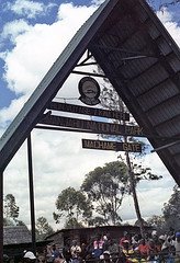
(Our Machame route starts at Machame Gate at 1,800m altitude but we'll experience the lower slopes during the drive from the town of Moshi to the start of our trek. More on the detail of our scary itinerary in a later article)
Between about 800-1,800m the Chagga people cultivate the rich volcanic soil for crops such as maize, coffee and bananas. The south and west sides of the mountain are wetter and more fertile, with rainfall varying from 500-1,800mm (20-70 inches) each year. (The Machame route is on the south side of Kili)
There are brilliant wild flowers and interesting vegetation supporting a wide range of bird life, including the common bulbul (brown with a black crest), the tropical boubou (didn't he used to be a mate of Yogi Bear's?), lots of brown speckled mousebirds and nectar feeding sunbirds (long curved bills and iridescent feathers)
2. Rain forest
The rain forest occurs between about 1,800-2,000m, with rainfall of about 2,000mm (80 inches) per year on the southern slopes. The west and north are much drier, and on the Rongai route the rain forest is sparser and less luxuriant (see the earlier article "Yes, but which way up" for a summary of each route). The forest often has a band of clouds, with mist and high humidity. Fine tall trees are decked with streamers of bearded lichen. Mosses and giant ferns flourish in these conditions, and wild flowers include violets, the occasional orchid and the unique red-and-yellow Impatiens kilimanjari, found nowhere else in the world
Common huge trees include Podocarpus milanjianus and camphorwoods. In the upper forest you start to see giant heather trees with yellow-flowered hypericum (St John's Wort) growing among them. Protea kilimandscharica is common around Maundi Crater and above Mandara
Fruit trees attract many birds: if you hear a bird braying like a donkey, it's probably a silver-cheeked hornbill. If you're lucky enough to see a large bird flashing crimson at its wings, it could be a turaco. Most animals are shy and easily hidden in the thick vegetation. You will probably see monkeys in the forest: blue monkeys and colobus (black with a flowing white mane of hair and thick white tail)


3. Heath and moorland
Between 2,800-4,000m are overlapping zones of heath and moorland, with rainfall ranging from 1,300mm (50 inches) a year on the lower slopes to 500mm (20 inches) higher up. Frost forms at night, and intense sunshine makes for high daytime temperatures

Heather and allied shrubs are well adapted to these conditions, the giant heathers (Erica arborea) having tiny leaves and thick trunks and growing to 3 metres high. You'll also see red hot pokers (Kniphofia thomsonii) standing to attention, and colourful Helichrysums

The moorland is dominated by giant groundsels (senecios and lobelias), especially near water courses. The most striking is Senecio kilimanjari, which grows up to 6 metres tall

The animal you are most likely to see is the tiny, semi-tame four-striped grass mouse (Rhabdomys pumilio), which has found its niche around the Horombo huts. From just above the forest upward, you will often see and hear the harsh croak of the white-necked raven, which scavenges successfully from the huts

4. High desert
The montane (high or alpine) desert zone stretches from 4,000m-5,000m and has low precipitation, less than 250mm (10 inches) a year. Here summer burns every day with mid-day temperatures of 35-40C (throw another shrimp on the barbie, Steve), whilst at night the winter chill bites deeply (unpack the long johns, Mrs M). Soil is scanty, and what little there is can be affected by solifluction; when the ground freezes, it expands and flows, disturbing plant roots. Only the hardiest can survive, such as the long-lived lichens (and hopefully The Kili 5)

The few plants that survive are slow-growing so care should be taken not to damage them

5. The summit zone
Higher up it is colder and drier still, and the slight precipitation (under 100mm or 4 inches a year) falls mainly as snow. This often condenses from clouds sucked up from below when air pressure drops because of the warming effect of the sun. There is no liquid water on the surface: it disappears into porous rock or is locked in as ice and snow


Living things must not only endure the blazing equatorial sun by day, but also arctic conditions by night. Here altitude defies latitude. With deep frosts, fierce winds, scarce moisture and less than 50% of the oxygen available at sea level, the environment is deeply hostile to any kind of life. Remind me why we're attempting this again.....

The highest flowering plant ever recorded was a small helichrysum in the crater at 5,670m. Animals are very rare, although in 1926 Richard Reusch found and photographed a snow leopard frozen in the snow. Hemingway immortalised it in his 1938 short story The Snows of Kilimanjaro, remarking that "no one has explained what the leopard was seeking at that altitude"

So there you have it. 1 mountain. 5 zones. A world of extremes. All in a week. Sounds amazing and scary in equal measure, eh? Stay tuned to this blog to see how we progress over the next 13 months until next February and the most interesting date any of us have probably ever been on (apart from when we met in The Old Emporium in Fleet obviously, Gill)